Andros Map
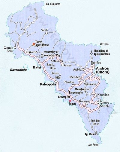
General map of Andros Island
On the map, you can see all the main roads. There are also local monasteries, and just as a matter of interest, the height of local hills and mountains. Travel agencies offer tours to Batsi, and another place worth seeing is Chora, the capital
Detailed map of Andros Island
On this map of Andros, you can see some of the resorts and beaches, and the basic road network.
The map will open in a new window; to go back, click on the ‘Back’ arrow in your browser.

Schematic map of Andros Island
with the main roads and resorts

Satellite map of Andros:
Maps of other Greek Islands:
Andros Map , Attika Map , Erikoussa Map , Chalkidiki Map , Chios Map , Ios Island Map, Ithaka Island Map , Kalymnos Map , Karpathos - Map of resorts and beaches , Kefalonia Map , Corfu Map , Kos - Map of resorts and beaches , Crete Map , Kythira Map , Lefkada - Map of resorts and beaches , Lesbos Island Map , Limnos Map, Meganissi Map , Mykonos Island Map , Naxos Map , Olympic Riviera Map , Parga Region Map , Paxos Island Map , Peloponnese Map , Rhodos - Map of resorts and beaches , Samos Island Map , Santorini Map , Skiathos Island Map , Skopelos Island Map , Syros Island Map , Thassos Island Map , Zakynthos Map